The PORT OF STEPHENVILLE (formerly Port Harmon) is located in Stephenville, Newfoundland and Labrador, Canada. The port services international and national ships, fishing, aggregate, container and special freight. PORT OF STEPHENVILLE is capable of accommodating most vessels, freight handling, storage and trans-shipments, and has a Custom Bonded Warehouse facility on the dock. PORT OF STEPHENVILLE is directly connected to the Trans Canada Highway (16 KMs Away) by Highway 490 (1.5 KMs Away). The Stephenville International Airport is adjacent to the PORT OF STEPHENVILLE. The area is also serviced by a regional hospital located in the town. The Town of Stephenville is the service center for a population of over 25,000 and has all services.
PORT FACILITIES:
PORT OF STEPHENVILLE operates year round and is a sheltered, deep sea and ice free port. The quay is 293m x 20m, with 7500 sq m of asphalt paved dock area. The depth is 10.1m at dockside. It can accommidate ships up to 385m in length. The turning basin has a 450m turning radius. Access to 2 boom cranes, a jib crane and 3 different capacity fork lifts of up to 8000 tonnes, to facilitate loading and unloading of containers and cargo at dock side. The 100,000 sq ft PORT OF STEPHENVILLE Warehouse Building is newly refurbished and has three 30 ton overhead cranes. Warehouse, Inventory and port operations personal are available.
PORT OF STEPHENVILLE operates according to the Canadian Federal Ports standards.
PORT OF STEPHENVILLE complies with "ISPS" code International and Port Facility Security Code of "IMO" International Marine organization.
PORT OF STEPHENVILLE has MARSEC Level 1 Security.
PORT OF STEPHENVILLE has a 24/7 Tug Service.
PORT NAME:
PORT OF STEPHENVILLE, Stephenville, Newfoundland and Labrador, Canada
LOCATION:
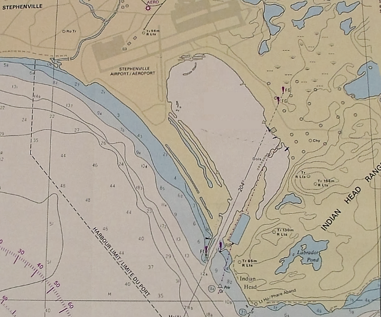
Located on the North shore of Bay St. George, approximately 50km east of Cape St. George. Navigational season is year round with occasional icebreaker assistance during winter months.
POSITION:
- Latitude: 48° - 31' - 46" N.
- Longitude: 58° - 31' - 30" W.
Canadian Hydrographic Service: Chart No. L/C 4885
Admiralty Chart: No. 283
Population: Stephenville 8000
Service Area Population: 25000
Time Zone: GMT – 3.5 Hours (NST)
Tidal Variation: 1.7 Metres (Spring)
Prevailing Winds: South Westerly
Water Density: 1026 kg per cubic metre
HABOUR ENTRY RESTRICTION:
The PORT OF STEPHENVILLE entrance channel is 72 meters wide by 2100 meters long dredged channel with green leading lights passing over a depth of 10 metres, reduced to lowest normal tide.
NOTE: Vessels with draft exceeding 10.0 metres, should contact the Harbour Master for further information, at 709-643-5626.
MARINE PAPERS REQUIRED:
- Crew Lists (3 copies)
- Passengers
- Stowaways
- Tobacco/Spirits/Personal Effects
- Certificate of Health
- Safety Equipment
- Tonnage Certificate
- Nationality Certificate
- Cargo Documents (3 copies of Customs Cargo Manifest)
- Cargo List of Dangerous Goods
MARINE VHF COMMUNICATION:
|
Port Call Sign: XLK482
| |||||
| Channel | Frequency | Power | Authorized Comms | ||
| 16 | 156.800 Mhz Tx/Rx | 5 Watt | Licensed Vessels only for Initial contact. All other uses prohibited. | ||
| 11 | 156.550 Mhz Tx/Rx | 5 Watt | Vessel Traffic Services | ||
| 12 | 156.600 Mhz Tx/Rx | 5 Watt | Vessel Traffic Services | ||
| 14 | 156.700 Mhz Tx/Rx | 5 Watt | Vessel Traffic Services | ||
| 81A | 157.075 Mhz Tx/Rx | 5 Watt | Canadian Coast Guard for Ship/Ship, Ship/Shore Comms Only | ||
POLICIES:
HISTORY OF PORT OF STEPHENVILLE:
- PORT OF STEPHENVILLE is positioned in Western Newfoundland, ideally located for shipping in North America, Atlantic Canada, Europe and the Arctic.
- A proud heritage... PORT OF STEPHENVILLE has served as a base for navel, commercial and government marine operations for national and international users.
- Constructed by the US Corps of Engineers in the early 1950s.
- Later operated by Transport Canada
- In 2003 it was privatized.
- In 2016 the name was changed from Port Harmon to Port of Stephenville.